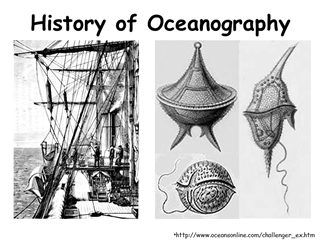
History of Oceanography, challenger_ Micronesian - Polynesian colonization of Pacific Ocean Islands
-
Upload
-
0
-
Embed
-
Share
-
Upload and view presentations on any device and embed the player to your website! --- > >Upload PPT
- Upload PPT
Download this Presentation

followed
unfollow
follow
0
Presentation Transcript
- 1.History of Oceanography http://www.oceansonline.com/challenger_ex.htm
- 2.Micronesian - Polynesian colonization of Pacific Ocean Islands 5000 – 1000 BP Micronesian & Polynesian colonized Pacific Islands Advanced Open Ocean Navigation Double Hull Canoes
- 3.http://www.monash.edu.au/APJCN/Vol4/Num4/44p361.htm
- 4.
- 5.Hurles et al 2003
- 6.Polynesian Colonization http://leahi.kcc.hawaii.edu/org/pvs/
- 7.Polynesian Sidereal Compass http://www.museum.upenn.edu/Navigation/sailing/
- 8.Polynesian Sidereal Compass http://www.museum.upenn.edu/Navigation/sailing/
- 9.Example Navigation Leg http://www.museum.upenn.edu/Navigation/sailing/
- 10.Early Ocean MappingPolynesians
- 11.
- 12.Mediterranean Cultures 6000 BP Egyptians boats with oars 3100-2850 BP Phoenicians travel through Mediterranean & up to England Mediterranean wide maritime trade Coastal settlements Coastal navigation
- 13.Phoenician Ships http://www.barca.fsnet.co.uk/phoenecian-ships.htm
- 14.http://go.hrw.com/venus_images/0298MC02.gif
- 15.http://www.mauigateway.com/~donjusko/final.htg/murexbrandaris_trunculus.jpg http://www.loretonh.nsw.edu.au/religion
- 16.Mediterranean Cultures 6000 BP Egyptians boats with oars 3100-2850 BP Phoenicians travel through Mediterranean & up to England Mediterranean wide maritime trade Coastal settlements Coastal navigation Greek and Roman Civilizations
- 17.http://www.nrlmry.navy.mil/~cannon/medports/Gibraltar/roll_cloud.html
- 18.
- 19.
- 20.Middle Ages Chinese Invent Magnetic Compass Vikings and Basque Travel to N. America Arabs cross navigate Indian Ocean Christopher Columbus “Discovers” America Juan Sebastian Elcano – First Round the World voyage (24 of 260 sailors) James Cook’s Voyages (chronometer)
- 21.
- 22.
- 23.Chronometer for Longitude
- 24.Lemons for Scurvey
- 25.
- 26.Benjamin Franklin & Timothy Folger (1769)
- 27.
- 28.Voyage of the HMS Beagle 1831-1836
- 29.Evolution of Coral Reefs Fringe reefs Barrier reefs Atolls
- 30.Edward Forbes (1840’s) Bottom Dredging in E. Mediterranean 8 Depth zones, based on different organisms AZOIC Zone below 600m Azoic Theory Too cold, too dark, no oxygen No Life
- 31.Challenger Expedition(1872 – 1876) HMS Challenger 226’ fixed rig Corvette 230 crewmembers; 7 Scientists 125000 km Objectives Map Ocean’s bottom Investigate the Azoic Zone Search for ‘Primitive Organisms’ (stable environment) Study Bathybeus haecklii (Huxley); “primordial slime”
- 32.HMS Challenger
- 33.HMS CHALLENGER 1872 – 1876
- 34.
- 35.
- 36.Challenger Expedition(1872 – 1876) Scientific Results - 50 Volumes (23 Years) Extensive Bathymetric Maps No Azoic zone Found temperature variability in deep waters (not all 4 oC) No Evidence of “primitive fauna” Description of 4717 new species Bathybeus haecklii = Alcohol precipitate of carbon sulphate Discovery Mid-Atlantic Ridge and Marianas Trench
- 37.SIO
- 38.WHOI
- 39.Ocean Resources
- 40.
- 41.
- 42.
- 43.http://www.greenet.pl/piosta/gal/bona_2_star.jpg
- 44.http://www.news.navy.mil/management/photodb/photos/030110-N-9851B-082.jpg
- 45.http://www.news.navy.mil/management/photodb/photos/960916-V-0000B-009.jpg
- 46.
- 47.http://www.photolib.noaa.gov/
- 48.Ocean Resources Fisheries Transportation & Trade Military Use Offshore Oil, Gas & Minerals Recreation & Aesthetics
- 49.Law of the Sea Treaty - 1973 Territorial Seas - 12 nm Procedures for Ocean boundaries Right of Free Passage through Straits Exclusive Economic Zones 200 nm Can extend out to 350nm Jurisdiction over: Fisheries Pollution Scientific Research Mineral Resources
- 50.www.whoi.edu
- 51.South China Territorial Claims
- 52.
- 53.www.bbc.co.uk/
- 54.Production ( million tonnes) 50 100 1800 1840 1880 1920 1960 2000 Year EEZs Claims Global Trend in Fishery Landings
- 55.Fishery induced changes in world fish composition
- 56.Greenhouse Effect
Related